")
")
")
")
")
")
")
")
")
Description
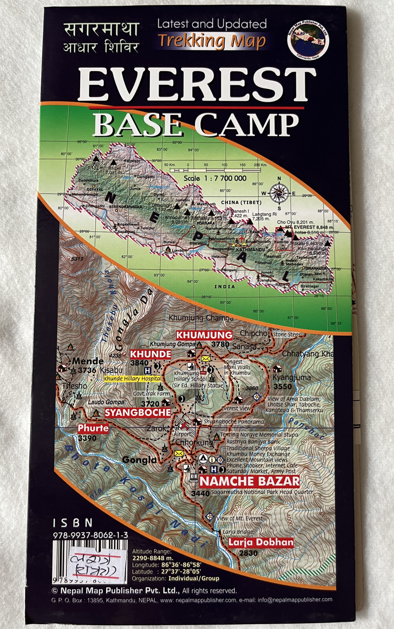
Everest Base Camp Trekking Map
Sagarmatha National Park | Scale 1:60,000 | Nepal Map Publisher Pvt. Ltd.
Product Details
-
Title: Everest Base Camp Trekking Map
-
Coverage: Everest Base Camp, Kala Patthar, Namche Bazaar, Lukla, and surrounding areas
-
Scale: 1:60,000
-
Publisher: Nepal Map Publisher Pvt. Ltd.
-
Edition: Latest and Updated
-
ISBN: 9789937806213
-
Language: English & Nepali
-
Material: Waterproof and tear-resistant
-
Best For: Trekkers, hikers, and mountaineers exploring Everest Base Camp and Sagarmatha National Park
Overview
The Everest Base Camp Trekking Map (Scale 1:60,000) is a must-have guide for trekkers heading to Everest Base Camp (5,364m) and Kala Patthar (5,545m). This detailed and updated trekking map provides precise routes, altitude markers, viewpoints, and cultural sites along the legendary EBC trail. Covering key locations such as Lukla, Namche Bazaar, Tengboche Monastery, Dingboche, Lobuche, and Gorak Shep, this map ensures you stay on the right path while trekking through the Sagarmatha National Park, a UNESCO World Heritage Site.
The Everest Base Camp trek is one of the most famous trekking routes in the world, offering spectacular views of Mount Everest (8,848m), Lhotse (8,516m), Nuptse (7,861m), and Ama Dablam (6,812m).
नेपाली अनुवाद - परिचय
यो एभरेस्ट आधार शिविर पदयात्रा नक्सा (१:६०,०००) सगरमाथा आधार शिविर (५,३६४ मि) र काला पत्थर (५,५४५ मि) सम्म पुग्न चाहने यात्रुहरूको लागि एक आवश्यक मार्गदर्शन नक्सा हो।
यस विस्तृत र अद्यावधिक नक्साले प्रमुख पदयात्रा मार्गहरू, उचाइ चिन्हहरू, दृश्यावलोकन बिन्दुहरू, र सांस्कृतिक स्थलहरू समेट्छ। नक्साले लुक्ला, नाम्चे बजार, तङबोचे गुम्बा, डिङबोचे, लोबुचे, र गोराशेप जस्ता महत्त्वपूर्ण स्थानहरूलाई समेट्छ, जसले युनेस्को विश्व सम्पदा क्षेत्र सगरमाथा राष्ट्रिय निकुञ्ज भित्र पर्ने क्षेत्रहरू दर्शाउँछ।
Key Features
✔ Covers Everest Base Camp & Sagarmatha National Park – Includes Kala Patthar, Namche Bazaar, Lukla, and surrounding areas
✔ Altitude Markers & Trekking Information – Provides elevation details, acclimatization points, and alternative routes
✔ Cultural & Natural Landmarks – Features Tengboche Monastery, Sherpa villages, suspension bridges, and glacial moraines
✔ Waterproof & Tear-Resistant – Ideal for harsh Himalayan conditions
✔ Updated & Detailed – Includes new trekking routes, side trails, and emergency exits
Interesting Facts
Everest Base Camp Trek Highlights
-
Everest Base Camp (5,364m) is the starting point for climbers attempting to summit Mount Everest (8,848m).
-
Kala Patthar (5,545m) is the best viewpoint to witness Everest’s summit up close.
-
Sagarmatha National Park is home to rare wildlife, including snow leopards, Himalayan tahrs, and red pandas.
-
Tengboche Monastery (3,867m) is the largest Buddhist monastery in the Everest region.
-
Namche Bazaar (3,440m) is the Sherpa capital and an important acclimatization stop.
-
The trek follows the Dudh Koshi River, crossing several high-altitude suspension bridges, including the famous Hillary Suspension Bridge.
नेपाली अनुवाद - रोचक तथ्यहरू
सगरमाथा आधार शिविर ट्रेक विशेषताहरू
-
सगरमाथा आधार शिविर (५,३६४ मि) बाट एभरेस्ट (८,८४८ मि) आरोहण गर्नेहरूको यात्रा सुरु हुन्छ।
-
काला पत्थर (५,५४५ मि) बाट एभरेस्टको शिखर सबैभन्दा राम्रो देख्न सकिन्छ।
-
सगरमाथा राष्ट्रिय निकुञ्ज हिमचितुवा, हिमाली थार, रातो पाण्डा लगायतका दुर्लभ वन्यजन्तुहरूको बासस्थान हो।
-
तङबोचे गुम्बा (३,८६७ मि) एभरेस्ट क्षेत्रको सबैभन्दा ठूलो बौद्ध गुम्बा हो।
-
नाम्चे बजार (३,४४० मि) यो क्षेत्रको मुख्य व्यापारिक केन्द्र र महत्त्वपूर्ण उचाइ समायोजन स्थान हो।
-
पदयात्रा मार्गले दुधकोशी नदी पछ्याउँछ र हिलारी निलम्बन पुल सहित थुप्रै उचाइमा रहेका झोलुंगे पुलहरू पार गर्नुपर्ने हुन्छ।
Publishers
Published by Nepal Map Publisher Pvt. Ltd., a leading provider of high-quality trekking maps for Nepal’s Himalayan regions.
We value your feedback!
Have you used this map on your trek? Leave a review to help other trekkers plan their adventure!
Hashtags
#EverestBaseCamp #EBCTrek #SagarmathaNationalPark #TrekkingMaps #ExploreNepal #EverestTrek #HimalayanAdventure #KalaPatthar #TrekkingInNepal #NamcheBazaar #HikingMaps #NepalMapPublisher


")
")
 Sagarmatha National Park Map Scale 140 000 Latest and Updated Climbing Map इम्जा त्से Nepal Map Publisher Pvt. Ltd. (9789937806299)")
 Sagarmatha National Park Map Scale 140 000 Latest and Updated Climbing Map इम्जा त्से Nepal Map Publisher Pvt. Ltd. (9789937806299)")
")
")
")
")